Shizuoka · Japan
Izu Skyline
D10Atami Pass to Izu
40.6 km ridge toll road down the Izu Peninsula spine with Mt Fuji and twin-bay views.
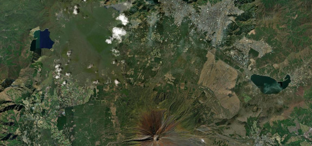
The Izu Skyline is a 40.6 km toll road running along the ridge of the eastern Izu Peninsula from Atami Pass south to Amagi Kogen, at elevations of roughly 170–730 m. Following the spine of the peninsula it acts as a natural balcony with Sagami Bay to the east, Suruga Bay to the west and Mount Fuji on the northern horizon, mixing long sweepers with tighter bends popular with drivers and riders. It is a paid toll road, exposed to ridge-top fog and wind, and patrolled for speed.
A toll road riding the spine of the Izu Peninsula within reach of Tokyo. Long, clean sweepers and ridge-top views make it one of Japan’s best-loved driving roads.
Why we picked it
Scenery
Best seasons
In these collections
In these guides
Where it runs25.1 mi · point to point
Navigate to the start: Apple Maps · Google Maps
Character
Corners
busiest around mile 15Elevation
under 4%4–8%over 8%177.2 – 724.4 mFrom the road
Points of interest3 stops
- Nishi-Tanna ParkingViewpoint4.0 mi in
- Yamabushi PassViewpoint7.7 mi in
- Kameishi PassViewpoint10 mi in
Hazards
- Ridge-top fog and crosswinds
- Toll road, payment required
- Speed enforcement and fast bike traffic
Sources
“long sweeping corners, tight bends and really is a joy to drive”
Verified route: mapped from real road geometry and fact-checked by a human editor. How roads get checked
Driving the Izu Skyline: quick answers
How long does it take to drive the Izu Skyline?
How difficult is the Izu Skyline to drive?
When is the best time to drive the Izu Skyline?
How much is the toll on the Izu Skyline?
Nearby roads
The closest great drives to Izu Skyline.