County Donegal · Ireland
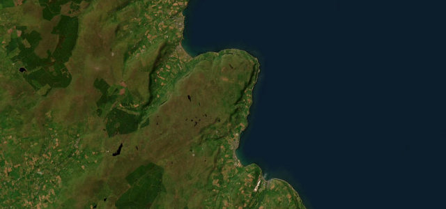
Mamore Gap
L1191Mamore Gap to Urris
A steep hairpin notch through the Urris Hills on Donegal’s Inishowen peninsula.
Mamore Gap is the dramatic high point of the Inishowen 100 on the Wild Atlantic Way, a steep narrow notch cut through the Urris Hills at around 250 m with a tight cluster of hairpins on the descent toward the coast. It is a short, properly challenging climb, more about commitment than flow, with a holy well and shrine at the top and big views over Lough Swilly. The 'magic road' gravity illusion sits nearby. Mind very steep gradients on loose single-track, blind hairpins with no barriers, and sheep on the open gap.
Scenery
Best seasons
In these collections
In these guides
Where it runs4.2 mi · point to point
Navigate to the start: Apple Maps · Google Maps
Character
Steeper than 9 in 10 roads here in the catalogue.
Corners
busiest around mile 2Elevation
under 4%4–8%over 8%13.5 – 259.8 mFrom the road
Points of interest2 stops
- Gap of Mamore ViewpointViewpoint1.6 mi in
- Mamore HillViewpoint1.0 mi in
Hazards
- Steep loose single-track
- Blind barrier-less hairpins
- Sheep on the gap
Sources
“Right after passing the very top of the pass an incredible panorama presents itself”
Verified route: mapped from real road geometry and fact-checked by a human editor. How roads get checked
Driving the Mamore Gap: quick answers
How long does it take to drive the Mamore Gap?
How difficult is the Mamore Gap to drive?
When is the best time to drive the Mamore Gap?
Nearby roads
The closest great drives to Mamore Gap.