Møre og Romsdal · Norway
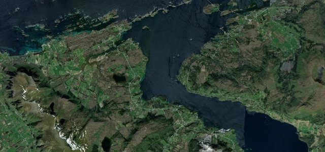
Atlantic Ocean Road
Fv6464Groravika to Kårvåg
A causeway of bridges leaping between Atlantic skerries.
The Atlanterhavsvegen threads a chain of low bridges and causeways across the skerries between Kårvåg and Vevang, the curling Storseisundet bridge its signature. Sublime in any weather, calm one minute, storm-lashed the next; mind the crosswinds, the fishing pull-offs, and waves over the road in a gale.
A low ribbon of bridges hopping between skerries, rising and dipping with the swells. Salt spray one day, calm and silver the next, we love it either way.
Why we picked it
Scenery
Best seasons
In these collections
In these Grand Tours
In these guides
Where it runs6.7 mi · point to point
Navigate to the start: Apple Maps · Google Maps
Character
Corners
busiest around mile 1Elevation
under 4%4–8%over 8%2.8 – 57.3 mFrom the road
Points of interest1 stop
- Vevang kystfortLandmark1.2 mi in
Hazards
- Crosswinds and waves over the road
- Cars stopping for photos
- Slippery in spray
Sources
“one of the most scenic drives in the world”
Verified route: mapped from real road geometry and fact-checked by a human editor. How roads get checked
Driving the Atlantic Ocean Road: quick answers
How long does it take to drive the Atlantic Ocean Road?
How difficult is the Atlantic Ocean Road to drive?
When is the best time to drive the Atlantic Ocean Road?
Nearby roads
The closest great drives to Atlantic Ocean Road.