Snæfellsbær · Iceland
Snæfellsnes Peninsula Coast
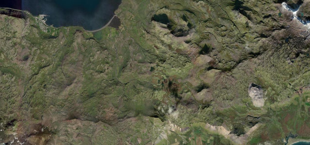
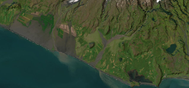
54Snæfellsbær to Ólafsvík
Paved heath pass crossing the Snæfellsnes Peninsula to Ólafsvík.
Route 54 crosses the Fróðárheiði heath over the Snæfellsnes Peninsula, climbing from the Búðir junction on the south side to a high point around 361 m before dropping to Ólafsvík, beneath the Snæfellsjökull glacier-volcano and past open lava fields. The road is paved and drivable in a standard car year-round. Mind the strong crosswinds and slower gravel detours on the inland north side.
Scenery
CoastMountain
Best seasons
SpringSummerAutumn
In these collections
In these Grand Tours
In these guides
Where it runs12.6 mi · point to point
SnæfellsbærStart · Snæfellsbær
ÓlafsvíkEnd · Snæfellsbær
Navigate to the start: Apple Maps · Google Maps
Character
Corners120bends
Tightness4of 10
Max gradient8%≈ 1-in-13
Climb544 mtotal ascent
Summit431 mhighest point of the line · 1,414 ft
Corners
busiest around mile 1Elevation
under 4%4–8%over 8%0.8 – 431 mPoints of interest2 stops
- FróðárheiðiViewpoint3.2 mi in
- ValafellViewpoint6.2 mi in
Hazards
- High crosswinds
- Single-lane bridges
- Loose gravel on side roads
Sources
“The 190 km road is entirely paved and passes through some of Iceland's most photogenic scenery including lava fields, waterfalls, fishing villages, mountain passes and the ever-present glacier on the horizon.”
Verified route: mapped from real road geometry and fact-checked by a human editor. How roads get checked
Driving the Snæfellsnes Peninsula Coast: quick answers
How long does it take to drive the Snæfellsnes Peninsula Coast?
Snæfellsnes Peninsula Coast runs 12.6 miles (20 km) and takes about 24 min to drive without stops.
How difficult is the Snæfellsnes Peninsula Coast to drive?
We rate it easy: 120 corners, a maximum gradient of 8%, and a tightness of 4 out of 10.
When is the best time to drive the Snæfellsnes Peninsula Coast?
Spring and Summer and Autumn are best.
Nearby roads
The closest great drives to Snæfellsnes Peninsula Coast.
Snæfellsnes Peninsula Coast
DirectionsGet the app